

The spectacular red rock country near Sedona, Arizona, hides an unusual and potentially hazardous geologic feature. The City of Sedona is surrounded by seven large sinkholes with potential for development of more sinkholes in the area. That is the subject of two reports by geologist Paul Lindberg published by the Arizona Geological Survey (see links below). The graphics in this article come from those reports.
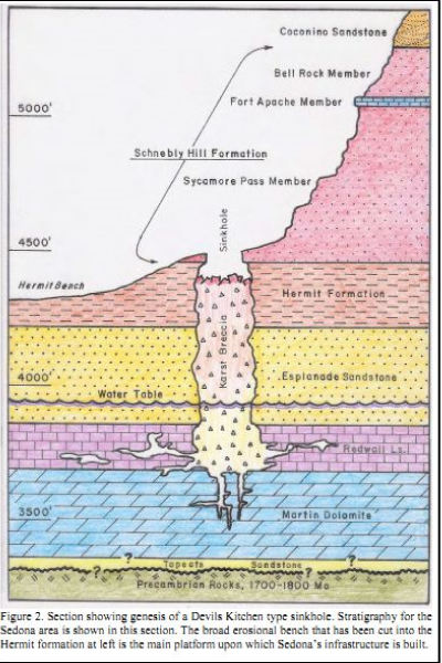
Sedona sinkholes are collapse features that form when surface, and near-surface rocks subside into caves in the Redwall Limestone, which lies more than 600 feet below the surface. Gradual collapse of the roof of the cave forms a breccia pipe that extends upward from the Redwall Limestone to the floor of the sinkhole and the surface. See cross-section below.
The Devils Kitchen sinkhole is the most active of the seven, with historic collapses in the 1880s, 1989, and 1995. The other sinkholes are in various stages of collapse, some beginning as early as the end of the last glacial epoch, about 10,000-years ago. Structures like this on the north rim of the Grand Canyon host uranium deposits.
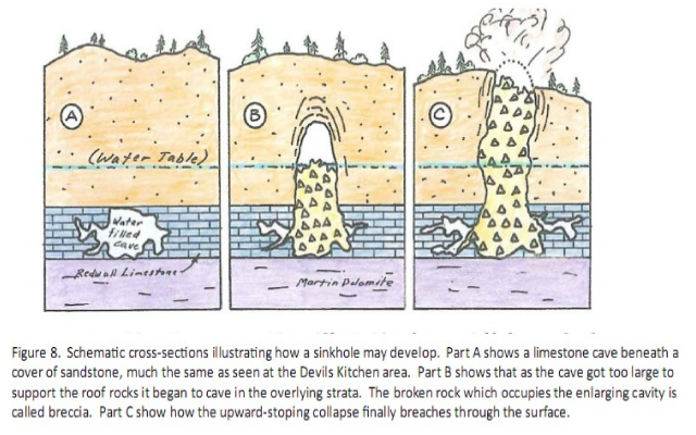
The following graphic (from the Devil’s Canyon report, cited below) shows how sinkholes develop.
The Sedona sinkholes range in size from about 225 feet in diameter by 100 feet deep at Red Canyon, to Sinkhole 4543, which is 13 feet in diameter and about 3 feet deep. Devils Kitchen, the best known of the sinkholes, has an opening 150 feet by 90 feet, with the floor situated 35 to 70 feet below the rim. Lindberg estimates that caverns in the Redwall Limestone could have volumes on the order of 1.3 million cubic feet (a cave roughly 100 feet high and 130 feet in diameter).
According to the report, the groundwater of the Middle Verde watershed, which fills the Redwall caverns, began as precipitation on the Colorado Plateau, near the western flank of the San Francisco Peaks above 6,900 feet. Groundwater passes beneath Sedona at a flow rate of approximately 15 million gallons per day.
Lindberg notes, “While the danger of future collapse is minimal to humans, unregulated septic leakage into hidden sinkhole breccias within the town limits could contaminate groundwater being tapped for municipal use ….” A second hazard, which could threaten hikers and sightseers, are the presence of sandstone overhangs at several sinkholes that could collapse without warning in the near future.
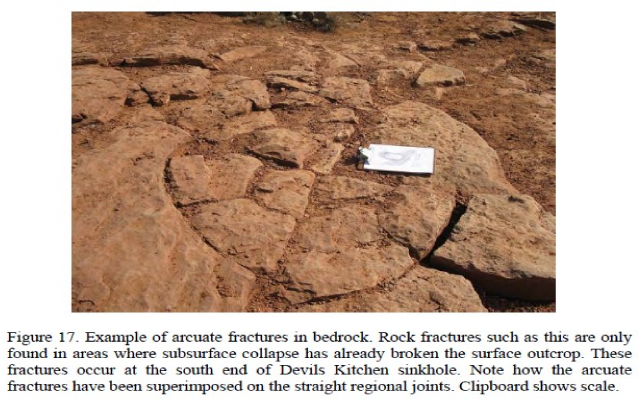
The arcuate patterns shown in the photo above represent a place where the rock has been stressed enough to break, but the rock has not yet collapsed. This may be the site of a future sinkhole. (I wonder if arcuate patterns such as shown above might have given rise to the legend of vortexes near Sedona?)
Lindberg’s reports include pictures, maps, and schematic, to-scale drawings of each sinkhole. The reports can be downloaded for free:
The general report on Sedona sinkholes (21 Mb) can be downloaded from:
http://www.azgs.state.az.us/publications_online/contributed_reports/cr10c.pdfhttp://www.azgs.az.gov/publications_online/contributed_reports/cr10c.pdf
A report specific to the Devil’s Canyon sinkhole (24 Mb) can be downloaded from :
http://www.azgs.state.az.us/publications_online/contributed_reports/cr10b.pdfhttp://www.azgs.az.gov/publications_online/contributed_reports/cr10b.pdf