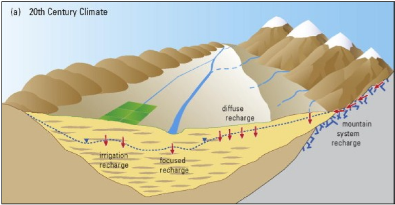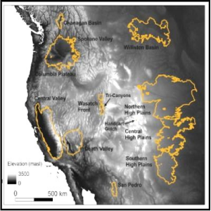
A group of 17 researchers, led by Thomas Meixner of the University of Arizona, attempted to assess the possible response of groundwater recharge to global warming in eight basins in the western U.S. In this context, “recharge” means the replenishment of water in aquifers from some surface source.
Implications of projected climate change for groundwater recharge in the western United States – paper review
Meixner et al, 2016, Implications of projected climate change for groundwater recharge in the western United States, Journal of Hydrology, Volume 534, March 2016, Pages 124–138. You can download the full PDF.
The authors assume future climate conditions will be as projected in the most recent National Climate Data Assessment (2014) which itself is very speculative and lacks any supporting physical evidence (see links to my articles below).
The authors acknowledge that their study comes with a great deal of uncertainty. That did not stop Tony Davis from asserting in the Arizona Daily Star that “groundwater recharge in the San Pedro will decline faster than in any of seven other Western groundwater basins…” Tony apparently did not read the part about the Central Valley of California nor the part about the San Pedro in the paper itself.
Here is an excerpt from the paper’s abstract:
“Eight representative aquifers located across the region were evaluated. For each aquifer published recharge budget components were converted into four standard recharge mechanisms: diffuse, focused, irrigation, and mountain-systems recharge. Future changes in individual recharge mechanisms and total recharge were then estimated for each aquifer. Model-based studies of projected climate-change effects on recharge were available and utilized for half of the aquifers. For the remainder, forecasted changes in temperature and precipitation were logically propagated through each recharge mechanism producing qualitative estimates of direction of changes in recharge only (not magnitude).”
“Several key patterns emerge from the analysis. First, the available estimates indicate average declines of 10–20% in total recharge across the southern aquifers, but with a wide range of uncertainty that includes no change. Second, the northern set of aquifers will likely incur little change to slight increases in total recharge. Third, mountain system recharge is expected to decline across much of the region due to decreased snowpack, with that impact lessening with higher elevation and latitude.”
“Factors contributing the greatest uncertainty in the estimates include: (1) limited studies quantitatively coupling climate projections to recharge estimation methods using detailed, process-based numerical models; (2) a generally poor understanding of hydrologic flow paths and processes in mountain systems; (3) difficulty predicting the response of focused recharge to potential changes in the frequency and intensity of extreme precipitation events; and (4) unconstrained feedbacks between climate, irrigation practices, and recharge in highly developed aquifer systems.”
In other words, this paper is long on speculation and short on physical data. Here is what they predict for each of the eight basins due to global warming:
High Plains Aquifer (aka Ogallala aquifer):
The paper projects moderate increases in recharge in the north and shifting to moderate decreases in the south or an overall net decrease in recharge depending on which data set is used.
San Pedro River:
The authors relied on two other studies which project a 30% and a 27% decrease in recharge over the next 100 years. However, the authors also note that depending which climate model was used, “Future recharge varied from a 100% decline in recharge to a 30% increase in recharge across the GCMs used.” That large range of uncertainty detracts from the value of the study.
Death Valley:
The paper predicts less recharge due to decreased snowpack in the surrounding mountains. That project is hedged: “Sources of uncertainty include potential increases in summer precipitation and winter precipitation intensity, which could lead to increased focused recharge. This source of recharge is currently so small that even large relative changes would result in negligible changes to total recharge.”
Wasatch Front Aquifers:
The paper predicts a general decrease in recharge (unless there is more snowpack).
Central Valley Aquifer:
Here, recharge is dominated by irrigation. Modeling projects decreases on anywhere between 5% and 60%.
Columbia Plateau:
There might be a modest increase in recharge if it rains more.
Spokane Valley-Rathdrum Prairie aquifer:
The authors don’t know because of the great uncertainty of the data.
Williston Basin aquifer system:
Some “considerations suggest that diffuse recharge to the Williston Basin may decline. However, model-based projections in multiple studies of future recharge to the northern HPA [high plains aquifer], located directly south of the Williston Basin, indicate that diffuse recharge will increase. Given these inconsistent outlooks, uncertainty in future diffuse recharge is high.” In other words, the authors don’t know about that one either.
The goal of this study was to provide information that would help planners form water policy for the future. Considering the high level of uncertainty, do you think this study will help?
Study funding: This study receive support from the U. S. Geological Survey and the National Science Foundation through a concurrent award (EAR-1328505). Additional support to several authors was provided by the USGS National Research Program and the USGS Office of Groundwater.”
Your tax dollars at work.
See also:
National Climate Assessment lacks facts, an analysis
National Climate Assessment = science fiction and politics
San Pedro River Geology – Implications for water law
Note to readers: I have constructed a linked index to more than 400 of my ADI articles. You can see it at: https://wryheat.wordpress.com/adi-index/
You can read my comprehensive, 28-page essay on climate change here: http://wp.me/P3SUNp-1bq

