The Arizona Geological Survey (AZGS) has just released a 53-page illustrated booklet about the Flagstaff area. You can download the booklet here.
According to Michael Conway, Chief of the AZGS, Geologic Extension Service, “This 53-page, Down-to-Earth booklet includes pictures, illustrations and jargon-free text to open the geology of northern Arizona to those who otherwise lack a geology background.”
General geology as described in the booklet:
The Flagstaff area is on the southern margin of the Colorado Plateau, a 130,000-square-rnile geologic province of vast plains, high mesas and buttes, deep canyons, volcanic fields and isolated mountain clusters. The landscape of this southern Plateau margin is dominated by the young San Francisco volcanic field and the underlying limestone-capped plateau.
The oldest known rocks underlying this part of the Plateau are 1.7-1.8 billion-year-old (Precambrian) granite and schist. These rocks, which make up the original crust of North America, were beveled by erosion and offset by faults that moved again during younger geologic periods.
Horizontal layers of sandstones, limestones, shales, and siltstones of the Paleozoic Era (544 million to 248 million years ago) were deposited on the ancient Precambrian rocks. These younger units, named in ascending order, the Tapeats Sandstone, Bright Angel Shale and Muav Limestone, Martin Formation, Redwall Limestone, Supai Group, Coconino Sandstone, and the Toroweap and Kaibab Formations, were deposited when this part of the continent was a shallow sea floor, a muddy tidal zone, a coastal plain crossed by silt-laden rivers, or a vast desert covered by sand dunes. The Coconino Sandstone and the Toroweap and Kaibab Formations are the only Paleozoic rocks exposed in the area covered by this guidebook.
More rock layers were laid down during the Mesozoic Era (248 to 65 million years ago). The Moenkopi Formation is the only Mesozoic rock that covers large parts of the Flagstaff area. Younger layers of sediment accumulated, but were later eroded away. The total thickness of sedimentary rock deposited during the Paleozoic and Mesozoic Eras may have reached 10,000 ft (3050 m), but much of this was stripped off by erosion.
Beginning about 65 to 75 million years ago, western North America was subjected to intense horizontal compression during an episode of mountain building called the Laramide Orogeny. The Rocky Mountains, for example, were formed during this period. This stress reactivated old faults and created new faults and folds. Vertical movement along these faults elevated the Precambrian basement rocks and the thick sequence of younger sedimentary layers thousands of feet, eventually forming the Colorado Plateau. The exact timing and causes of the uplift are still debated by geologists.
In the Flagstaff area movement along faults deformed once-horizontal layers into long folds, such as the Black Point monocline north of Wupatki National Monument. The uplift also caused formerly sluggish rivers to cut deep canyons into the younger sedimentary layers.
Beginning about 25 million years ago, the crustal rocks of western North America were stretched, thinned, and broken along steep faults. Movement occurred again along the old faults of the Flagstaff area. About 6 million years ago, molten rock (called magma inside the earth and lava when it erupts) migrated upward along some of these fractures and flowed onto the land surface as lava flows. As eruptions continued during the period 3 million to 1000 years ago lava of the San Francisco volcanic field poured onto, exploded through, or was injected into Paleozoic and Mesozoic sedimentary layers of the plateau.
Finally, San Francisco Mountain, the high stratovolcano that towers over the volcanic field, was scoured by glacial ice several times during the last 1.8 million years. Today, running water is cutting into and wearing down this southern flank of the Colorado Plateau.
The geologic features described and illustrated in the booklet include:
- San Francisco Volcanic Field
- Lava Dome: Mount Elden
- Stratovolcano: San Francisco Mountain
- Glacial features: Cirques, Moraines, and U-shaped Valley
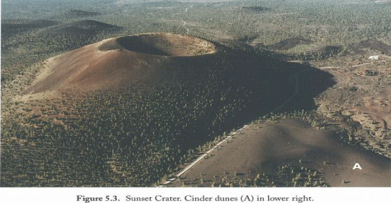
- Young Cinder Cones and Lava Flows: Sunset and SP Craters
- Squeeze-up: Bonito Flow
- Cinder Dunes and Ventifacts
- Moenkopi Formation: Wupatki National Monument
- Blowhole: Wupatki National Monument
- Fault-aligned Cinder Cones: Wupatki National Monument
- Sinkhole: Wupatki National Monument
- Graben: Wupatki National Monument
- Folding: Black Point Monocline
- Entrenched Meanders: Walnut Canyon National Monument
- Kaibab Formation: Walnut Canyon National Monument
- Coconino Sandstone: Walnut Canyon National Monument
- Stream Displaced by a Lava Flow: Grand Falls
- Meteor Impact Crater: Barringer Meteor Crater
- Laccolith: White Horse Hills (Marble Mountain)
- Anatomy of a Cinder Cone: Red Mountain
- Tafoni: Red Mountain
- Hoodoos (Demoiselles): Red Mountain
- Lava Tube: Lava River Cave
Note to readers:
- Index with links to all my ADI articles: http://wp.me/P3SUNp-1pi
- My comprehensive 28-page essay on climate change: http://wp.me/P3SUNp-1bq
