

PHOENIX — An approaching storm system from the west will make for some photogenic, but dangerous weather conditions across Arizona today.
Overnight, storms moved into the east Valley, dropping more than an inch of rain in parts of Mesa and Apache Junction. Flash flood warnings are in effect for these cities until at least early afternoon.
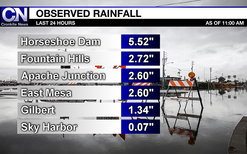
Graphic by Jordan Evan/Cronkite News
Water rescues now on 3TV in Apache Junction. Watch on air, on our app or online. https://t.co/F5Y8DsXjWW #azwx #azfamily pic.twitter.com/Yb5UNTkQ36
— Ian Schwartz (@SchwartzTV) September 23, 2019
The National Weather Service has issued flash flood watches for a large part of the state, including metro Phoenix, Tucson and Kingman.
Flash flooding will not be the only concern with today’s storms. Thunderstorm activity is expected to pick up in the early afternoon over the Valley, and could last into the overnight hours.
The National Weather Service is expecting these storms will pose multiple threats, including large hail and damaging winds.
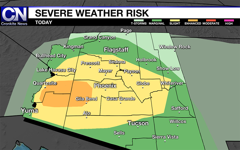
Graphic by Jordan Evan/Cronkite News
The Storm Prediction Center has placed all of Maricopa County, and parts of Pinal, Gila, Yavapai, Yuma, Pima and La Paz counties under a slight risk of severe weather. There is also an enhanced risk for La Paz, Yuma, and western Maricopa counties, this includes the city of Buckeye. This means these areas will be the most likely see severe weather.
These thunderstorms could produce large hail and damaging winds in excess of 60 mph, heavy rains and lightning. There’s also an isolated tornado risk for the enhanced risk area.
The atmospheric set up

Graphic by Jordan Evan/Cronkite News
Current analysis shows the system is positioned over the California and Nevada state line.The system is expected to track to the southeast towards Arizona, which will amplify storm activity throughout the day across the state.
Out ahead of it, rich moisture from the remnants of tropical storms Lorena and Mario, which were nearly parallel to each other, is fueling the atmosphere. Since dissipating over the weekend, the remnant moisture has made its way northward over Mexico and into Arizona.
Now an intense area of low pressure is tracking south over the Great Basin. The position of this low is allowing a lot of ingredients to come together to make for an active weather day.
The current atmospheric set up is similar to two previous severe weather events over Arizona. In late September 2014, an intense line of thunderstorms moved through the Valley and central Arizona bringing high wind gusts near 70 mph that damaged some of the terminals at Sky Harbor International.
In early October 2010, Phoenix saw its largest hailstone ever, at three inches in diameter. That is equivalent to nearly the size of a baseball. This was a rare event for Phoenix, as hail this big primarily occurs over the Great Plains. This was also the same storm system where multiple tornadoes touched down in the high country, including one that damaged homes in Bellemont.
What you need to know
As hail the size of baseballs and tornadoes are extremely rare in Arizona, they are still not out of the question for today. It is important for you to have a plan of action incase severe weather impacts your area.
If a thunderstorm is approaching, make sure you have a safe and sturdy structure to seek shelter in. The National Weather Service also recommends to stay away from windows, and avoid using corded electrical equipment. If you are in a vehicle, safely drive to a sturdy structure for shelter.
Keep in contact with loved ones by creating a communication plan. Prepare your home by securing loose objects outside, and closing doors and windows.
Have extra batteries and chargers for your cell phone ready, incase you are to lose power. More safety tips about how to prepare for severe weather can be found here.
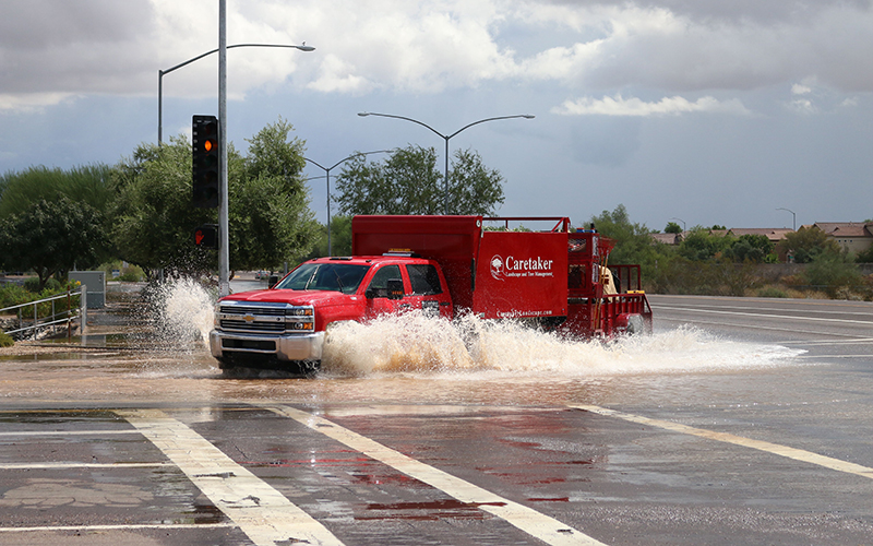
Most importantly, do not drive into flooded roadways. It only takes 12 inches of water to float compact vehicles.
Video by Jordan Evans/Cronkite News