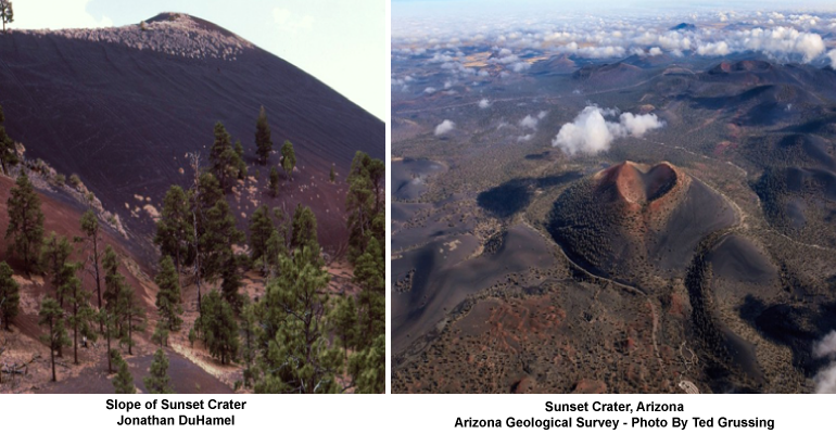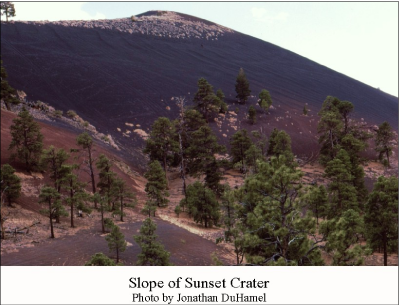
Sunset Crater lies within the San Francisco volcanic field about 15 miles northeast of Flagstaff. Volcanism began in the San Francisco field about six million years ago and culminated with the eruption at Sunset Crater sometime between 1040 A.D. to 1180 A.D. The volcanic cone is 1,000 feet high and about one mile in diameter at the base. The crater is about 400 feet deep.
Prior to eruption, the area was a forested valley occupied “by settlements of hunters and gatherers that lived in pit houses and grew corn to supplement their diet. Archaeologists refer to these people as the Sinagua, which is a contraction of the Spanish words ‘sin’ and ‘agua’ meaning without water. The Sinagua were the ancestors of the Pueblo Indians of the Four Corners area, including the Hopi Indians who refer to them as Hisatsinom (those who lived long ago). The lives of these people were profoundly changed in the late 11th century when a volcano was born.” (Hanson).
Sunset Crater is the last one of several cones that erupted along a 6-mile-long fissure.
According to the USGS, about 75% of the magma at Sunset Crater erupted explosively as scoria. About half of the scoria fell very near its source and built Sunset Crater cinder cone, the rest blanketed the region with ash and other small volcanic particles. About 25% of the magma was erupted as lava flows.
There has been some controversy about the dating and duration of eruptions. These are explained in detail by Hanson (referenced below). Hanson favors a short eruption duration: a few months to several years:
“Extensive field examinations reveal no weathering and/or erosion horizons within the layered blanket of fallout cinders suggesting that the pulses of activity all occurred within a short period of time. The lack of geochemical variation between the cinder eruptions and lava flows, as well as the recent paleomagnetic and dendrochemical studies, are also consistent with a much shorter eruption duration. A later eruption of shorter duration also correlates with population increases at pueblo villages such as Wupatki (~AD 1100), which may be related to enhanced agricultural conditions subsequent to the eruption of Sunset Crater.”
Hanson also notes:
“During the waning stages of the eruption, cinders on the rim were oxidized to a red scoria and cemented by silica, gypsum and iron oxide. Five distinct fumarole incrustations are present near the central vent of the volcano. These incrustations are composed predominantly of gypsum which is locally overgrown with opal or a thin coating of sulfur. Numerous accessory minerals, including voltaite, jarosite, magnetite and hematite, occur throughout. One mineral, ferrohexahedrite, is new to the state of Arizona. This eruption was most certainly witnessed by the ancestors of today’s Pueblo Indians. The lava fountain would have been visible from quite a distance, perhaps 30 to 50 kilometers, and the ash plume for hundreds of kilometers.”
After the eruption, the area within about 20 miles of the crater was unsuitable for agriculture.  However, farther out, land was covered by a thin layer of ash which acted as a water-retaining mulch, thus enhancing agriculture. Archaeologists suggest a rapid growth of population in the area after the eruptions ceased.
There was some excitement on October 31, 2009. More than 120 discrete earthquakes, most M 2.0 or greater, occurred over a six-hour period, on a northeast trend with a distinct shallowing to the southwest adjacent to Sunset Crater. According to the Arizona Geological Survey, “the combined factors of a lack of a mainshock and aftershock sequence, the depths and periodicity of the events points to a volcanogenic source mechanism” for the earthquakes..
There was more excitement on June 4, 2015 when a “steam cloud” was reported coming from the crater. Alas, it was just smoke from a forest fire.
You can take a virtual tour of Sunset Crater here.
Pumice has been mined from San Francisco Mountain for industrial use and landscaping. Several years ago there were some shady gold mining ventures in a few of the cinder cones. I remember because as a geologist I examined one. See the story on my Wryheat blog: The Cinder Cone Caper .
For a brief history of the geology of Arizona, see these ADI articles:
A Brief Geologic History of Arizona Chapter 1 Precambrian
A Brief Geologic History of Arizona Chapter 2 Cambrian and Ordovician time
A Brief Geologic History of Arizona Chapter 3 Silurian to Permian
Arizona Geological History Chapter 4: Triassic Period
A brief geologic history of Arizona Chapter 5: Jurassic Time
A brief geologic history of Arizona Chapter 6: Cretaceous Time
A brief geologic history of Arizona Chapter 7, the Cenozoic Era
For more information on Arizona’s volcanic fields see my Wryheat post:
Young Volcanic Fields of Arizona
References:
Hanson, Sarah, 2009, Sunset Crater Volcano A Cinder Cone Eruption That Impacted the Ancestral Puebloan Indians, Arizona Geological Survey, Arizona Geology (article available online)
Sunset Crater Volcano National Monument, 2005, National Park Service
