
Sometimes mines just vanish. Such seems to be the case with the Pontatoc mine located near the north end of Pontatoc Road in Tucson just below the Santa Catalina Mountains. The map below shows the general location (at the balloon). I will show a more detailed location farther down the post.

The Pontatoc mine was discovered in 1906 and worked until 1917. It produced about 5,000 tons of copper, silver, gold, and molybdenum ore. Mindat.org reports that hand-picked ore assayed at 4% copper, 0.5 ounces per ton silver, and a trace of gold.
Mineralization occurred in a wide altered breccia zone along the Catalina foothill fault dividing Catalina Gneiss, a Laramide age metamorphic rock, from Tertiary to Quaternary age Pantano conglomerate beds. “Ore occurred in the fault zones wherever rock alteration is intense….Sulfides precipitated with quartz,” according to Mindat.org.
Workings consisted of two shafts, one 105 feet deep, the other 125 feet deep, plus a pit and tunnel operations. The Pontatoc mine is described in the Pusch Ridge wilderness study by George S. Ryan (See reference below). According to Ryan, Pontatoc Ridge was intensely prospected shortly after the production from the Pontatoc mine itself. There were several shows of oxide copper on the ridge, but apparently they didn’t amount to much.
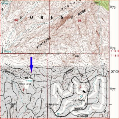
The topographic map below shows a mine symbol (a square half filled in) near the intersection of East Coronado Drive and East La Poloma Drive.
Ryan’s paper puts the mine at this location.
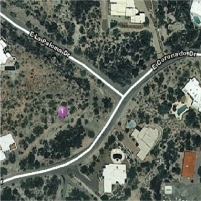
If this is in fact the location, it is now covered with a house. I drove out to the area to look around. While Ryan puts the mine just south of East Coronado Drive, I think at least part of the mine may have been just across the street to the north in the triangle formed by La Paloma and Coronado. The next graphic shows a closer look at the corner, followed by a detailed photo of a disturbed area in the triangle.

The detailed picture shows a cliff that may be a scarp of the fault in which the mineralized breccia developed. Although the ground is disturbed, there is no trace of the pit or shafts, presumably they have been filled in. It is interesting, though, that this particular lot has not been developed. This fault is apparently inactive, so homeowners shouldn’t worry.
By the way, Ryan reports that gypsum was mined from Tertiary lake beds in the same area and used for plaster in the Tucson building industry prior to 1966.
Some mines have fleeting glory then just disappear. Such is the case of the Pontatoc mine.
Reference:
Ryan, George S., 1982, Mineral Resources Investigation of the Pusch Ridge Wilderness Pima County, Arizona, U.S.B.M. open file report MLA 118-82.
See other stories:
The Gold of Cañada del Oro
Old mines of the Tucson Mountains
Beneath the Tucson Valley
When is a mine mined out?