
The timing of origin of the Grand Canyon and Lower Colorado River has been a controversial topic within the geological community. ADI recently ran a story: “Did Dinosaurs Roam The Grand Canyon?” That story says “no.” I agree.
Back in 2012, researchers from the University of Colorado and California Institute of Technology published a paper which claimed that the Grand Canyon was carved 70 million years ago. The research involved isotopes and two very complex and complicated laboratory techniques. The Arizona Geological Survey published a rebuttal article by Wayne Ranney, a geologist who has long studied the canyon and has written a book about it. Ranney politely opined that the technique used by the researchers “is not as evolved as one might hope for. Some assumptions are made that could result in different outcomes.” (See more on this story in my Wryheat article “Grand Canyon age controversy heats up.”
Here is my opinion on this controversy based on geologic evidence from several sources, principally from the Arizona Geological Survey.
The Colorado Plateau initially tilted to the northeast and rivers, including the ancestral Colorado River, flowed in that direction into Utah and Colorado. A deep canyon could have been cut into Utah. Beginning about 18 million years ago, crustal stretching formed the Basin and Range province west and south of the plateau. (See my ADI article “The Basin & Range Province of North America“)
Also around this time, plate tectonic adjustment began to tilt the Plateau toward the southwest. By 10 million years ago, plate tectonic movement began to open the Gulf of California and a river at its north end began to cut northward. At about the same time, the northeastward flowing rivers of the Colorado Plateau reached the southern escarpment of the plateau and began to flow south forming lakes along what is now the course of the lower Colorado River. Actual cutting of the Grand Canyon we see today probably began about 5.5 million years ago. (See my Wryheat article: “Origin of the Grand Canyon” for more detail.
A detailed study of the Bouse Formation along the lower Colorado River supports a young age for the river and canyon. The best documented hypothesis was put forth by Philip Pearthree of the Arizona Geological Survey, Kyle House (now with USGS), and Michael Perkins (Univ. of Utah). Their paper, “Stratigraphic evidence for the role of lake spillover in the inception of the lower Colorado River in southern Nevada and western Arizona,” Geological Society of America Special Paper 439, has been awarded GSA’s prestigious Kirk Bryan Award for Research Excellence for 2013. (The paper is pay-walled at GSA but you can download the full paper here, 26.8 Mb.)
These authors propose that as the ancestral Colorado River cut through the Colorado Plateau and began to flow south, the water filled a series of basins from north to south, one at a time. When the northernmost basin was filled, it breached the natural dam on its south side, and filled the next basin to the south. This process was repeated until the river reached the Gulf of California.
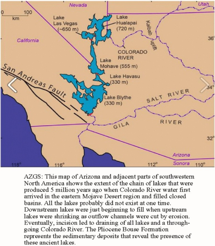
An earlier competing hypothesis proposes that an estuarine river cut northward from the Gulf of California, to form the Lower Colorado River. This hypothesis was initially supported by the presence of limited marine fossils in the lowest member of the sediments along the river. House, Pearthree, and Perkins counter this by proposing that:
“The lowermost Bouse lake would have encompassed an immense area extending from Parker Valley to the Chocolate Mountains and westward into a series of low-lying basins in the Mohave Desert. Recent hydrologic modeling suggests that it may have taken tens of thousands of years to fill this extensive lake to overflowing due to likely high rates of evaporation; consequently, the lake water could have become quite saline prior to spilling into the Yuma area. This might have allowed salt-water fauna to survive in the lake, but the mechanism for transportation of marine fauna into such a lake, if it existed, is disputed.”
In addition, they found that “strontium isotope ratios in Bouse carbonates throughout the extent of the deposit are more similar to modern Colorado River water than to seawater.” Also, the northward cutting river hypothesis requires over 1,800 feet of uplift along the river after the lake sediments were deposited.
The timing of deposition of the sediments recording lake formation can be precisely dated because of interspersed volcanic ash deposits. The lakes began to form 5.5 million years ago which must have been the time of the inception of cutting the Grand Canyon as we now know it. The rocks tell the story; we just have to learn how to read it.
For more geologic history of Arizona, see:
A Brief Geologic History of Arizona Chapter 1 Precambrian
A Brief Geologic History of Arizona Chapter 2 Cambrian and Ordovician time
A Brief Geologic History of Arizona Chapter 3 Silurian to Permian
Arizona Geological History Chapter 4: Triassic Period
A brief geologic history of Arizona Chapter 5: Jurassic Time
A brief geologic history of Arizona Chapter 6: Cretaceous Time
A brief geologic history of Arizona Chapter 7, the Cenozoic Era