

A large deposit of rare, brilliant white marble sits on the north slope of the Dragoon Mountains, within Coronado National Forest, near the small town of Dragoon, Arizona, between Benson and Willcox. This deposit, with marble comparable to the famous Carrara marble from Italy, was mined from 1909 to 1965 and its products were used in many office buildings and homes in Arizona and California. The deposit is contained within the Escabrosa formation which, when metamorphosed by an intrusive, can become very finely crystalline marble, and the Dragoon deposit is one of the best of this type.
In 1998, Alpha Calcit Fullstoff, an international producer of ground calcium carbonate, through its American subsidiary Alpha Calcit Arizona, acquired the unpatented mining claims on the property. Pilot testing, using proprietary optical scanning technology showed that the marble was suitable for premium quality, high brightness coatings and fillers used in the production of fine white paper.
Testing continued and by 2002 the Coronado National Forest approved a Plan of Operations and a Notice of Intent to file an environmental impact statement.
At a scoping meeting, a Forest Service geologist, apparently inexperienced with this type of deposit, erroneously concluded that the marble deposit was not locatable (could not be acquired by staking claims) under the Mining Law (see definition). The Forest Service geologist maintained that the marble was of a common kind that must be leased instead of acquired by staking a claim, even though the claims had existed for many years. The geologist failed to consider the color, physical, and chemical properties of the marble that would allow production of ground calcium carbonate products. That conclusion resulted in a campaign by environmental radicals which caused the Forest Service to cancel the Plan of Operations.
However, following independent metallurgical testing at the North Carolina State University Minerals lab, which showed that the marble did indeed have special qualities, the Forest Service decided that the quarry could be operated under regulations for locatable minerals and allowed exploration and testing to continue. But another problem arose.
During this time, Coronado National Forest was engaged in the now infamous RARE II phase of the Roadless Area Review and Evaluation program. This was a program, prompted by the Wilderness Act of 1964, to assess areas of National Forest for inclusion in wilderness areas.
The criteria for inclusion in an official roadless area include:
- The area had to have “Natural appearing landscapes with high scenic quality.”
- The minimum size for consideration is 5,000 contiguous acres.
- The roadless area had to be… roadless.
Ignoring these criteria, the Forest Service created the 1,164 acre, Upper Dragoon Roadless Area which contains the mine and its road.
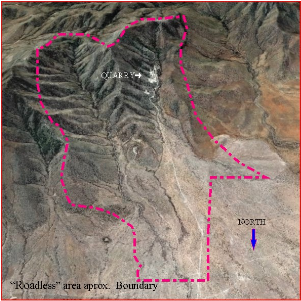
The road into the quarry (see photo above), one of two roads in the “roadless area,” predates Arizona statehood. The road, originally called Dragoon Marble Quarry Road, was renamed Lizard Lane and became a dedicated county road in 1924 and is listed as Forest Service road 689 on forest maps.
Internal Forest Service memos, obtained by Alpha Calcit via an FOIA action, show Forest Service personnel writing: “The marble quarry is a drastically disturbed site, that is, all soil and vegetation has been removed over an area of approximately 14 acres. The entire area is surfaced by fractured rock. This type of disturbance is not consistent with roadless area characteristics.”
A 2004 Forest Service memo states, “At the time of authorization, the site was not in a designated roadless area.” Nevertheless, “The area was inadvertently included when the map was created that displayed designated roadless areas.” If it was a mistake, it is an amazing coincidence because the boundary of the roadless area looks like it specifically targets the marble quarry.
So, the Upper Dragoon Roadless Area officially exists, hindering development of the marble mine even though such a designation fails on establishment criteria and the Forest Service admits it was created by mistake. That “mistake” remains uncorrected.
The Forest Service finally approved a new Plan of Operations in 2006. But, the Forest Service now says that mining will “substantially alter the undeveloped character” of the roadless area, contradicting their own memo which stated “The entire area is surfaced by fractured rock. This type of disturbance is not consistent with roadless area characteristics.” The Forest Service required another Plan of Operations (the third one) which was submitted in December, 2015, at considerable additional expense to Alpha Cacit. The Forest Service is still nitpicking that plan and requires additional information. That’s how it stands. There is still a question of whether or not a very expensive Environmental Impact Statement will be required.
It has been 14 years since the first Plan of Operations was approved, but the Forest Service keeps moving the goal posts. And as of April, 2016, the Forest Service still has not corrected its “mistaken” designation of the quarry area as a roadless area, even though the designation fails three required criteria as stated above.
According to geologist Ted Eyde, project consultant for Alpha Calcit: “if the Alpha Calcit Project which began in 1998 and had come into production in 2005 as planned [they] would have invested over $40,000,000 in capital expenditures during quarry development and plant construction. The plant and quarry would have 23 employees many of whom would have resided in Willcox. The payroll would be over $1 million a year plus operating expenses, equipment and services paid locally would amount to an additional $2 million a year. The bottom line is that Willcox and Cochise County would have received $30 million over the 10 year period. Instead, Willcox and Cochise County are planning to approve pot farms to provide income. And, this does not include the thousands of dollars of taxpayers money spent by Coronado National Forest to stop the project.”
Instead, according to an article by Dr. Robert Carreira CER Chief Economist published in the Wilcox Range News: “Local households in Cochise County worse off than in 2007.”
The bogged-down, politically correct, bureaucracy is killing jobs, capital expenditures, and tax revenue for local school districts, Cochise County, and the state of Arizona. That’s your taxpayer dollars at work.
I note that the State of Wyoming and the Colorado Mining Association have petitioned the U.S. Supreme Court to invalidate the federal government’s Roadless Area Conservation Rule. The petitioners argue the U.S. Forest Service exceeded its authority in enacting the Roadless Rule by exercising power reserved solely for Congress. The roadless areas are de facto wilderness. The 1964 Wilderness Act says Congress alone designates wilderness areas.
See photos of the quarry from Desert Rambler here.
Related: The I-10 copper deposit (This deposit lies just a few miles north of the quarry.)
Note to readers: I have constructed a linked index to more than 400 of my ADI articles. You can see it at: https://wryheat.wordpress.com/adi-index/
You can read my comprehensive, 28-page essay on climate change here: http://wp.me/P3SUNp-1bq