

The Chiricahua Mountains of southeastern Arizona where once the site of very explosive volcanic eruptions. They now host some very interesting rock formations including hoodoos, rock spires, and balanced rocks. (All are erosional forms which develop into fantastic pinnacles, towers and grotesques shapes. Hoodoos have a cap rock.)

Like the Tucson Mountains, the Chricahuas have had several periods of volcanism. The principal and most explosive episode began about 27 million years ago.
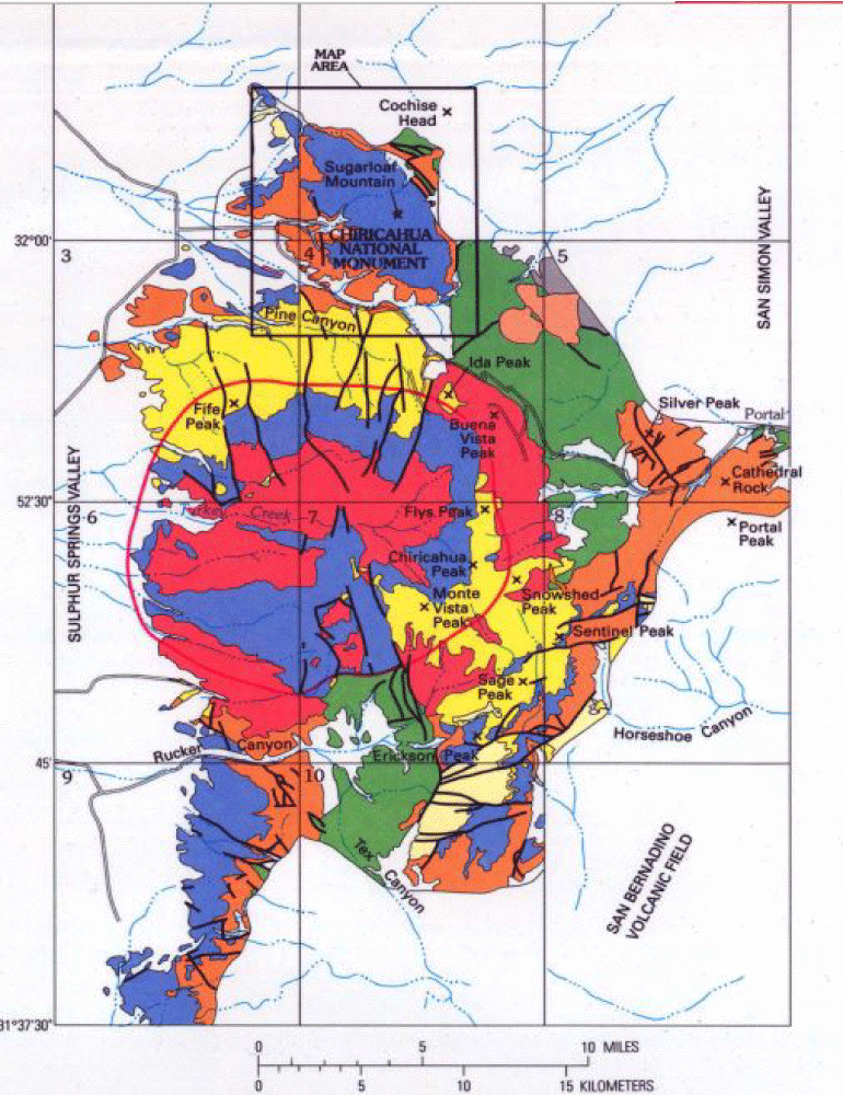
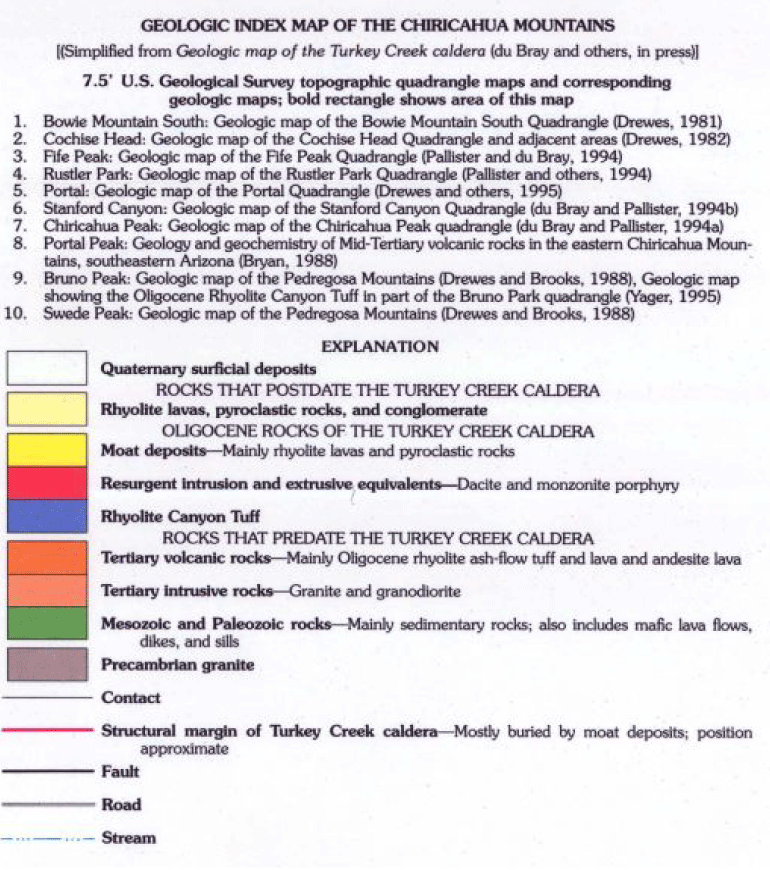
As described by the U.S. Geological Survey (see reference below), “a large mass of magma accumulated within a few miles of the surface, forming a magma chamber” just to the south of where Chiricahua National Monument occurs in the northern part of the range.
“Eventually, the overlying rock ruptured and the resulting decrease in confining pressure allowed volatiles (mostly water vapor and carbon dioxide) to separate from the magma and form gas bubbles. Foaming magma formed pumice and expanded as much as 50 times in volume, causing a series of large explosive eruptions. The eruptions blew more than 100 cubic miles of magma out of the volcano and buried a region of at least 1,200 square miles in a thick blanket of hot ash and pumice. For comparison, the 1980 eruption of Mount St. Helens produced only one tenth of a cubic mile of magma and the 1991 eruption of Mount Pinatubo in the Philippines, which was one of the largest eruptions of the century, produced only about one cubic mile of magma.”
The USGS report notes, “The eruption produced boiling clouds of very hot (greater than 1,000°F) ash, pumice, rock fragments, and gas that were propelled into the atmosphere and across the land surface at speeds of 50 to more than 100 miles an hour, scouring everything in their paths like superheated jets from a sandblaster. As the clouds lost gas and deflated, they became more dense and flowed downslope from the volcano as pyroclastic flows that ponded in valleys to form thick deposits of steaming ash and pumice.” As the still-hot ash and pumice came to rest is compacted and fuse into a rock geologists call welded tuff.
Eruption of that great volume of magma caused the magma chamber to collapse in on itself to form a caldera (now called the Turkey Creek caldera) that was about 12 miles in diameter and at least 5,000 feet deep. The caldera was partially filled by some of the just-erupted ash and by subsequent eruptions.
Following the explosive ash eruption, an eruption of less-volatile lava covered most of the caldera and prevented much of the tuff from being eroded away.
During the 20 million years following eruptions, large faults cut the volcanic edifice and dropped part of it down to form the San Simon Valley on the east and the Sulphur Springs Valley on the west.
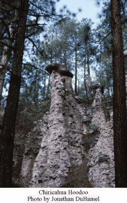 Also during that time, water and wind eroded the welded tuff along fractures to produce the weird shapes we see today. The USGS opines, “Recent study has shown that contrary to previous ideas, the joints were not produced as the tuff was squeezed and fractured between faults, as if in a vise. If that were the case, one would expect to see a systematic pattern in the orientation of the joints. Instead, the joint directions vary widely and they curve, features that indicate they resulted mainly from contraction brought about by the original cooling of the tuff. Cooling joints form at right angles to surfaces where heat is removed from a lava flow or tuff layer; these are mainly the top and bottom surfaces and the resulting joints are usually vertical planes. The intersection of joint planes form rock columns.”
The USGS calculates that the rock spires and columns are about 2.4 million years old based on the local erosion rate of the tuff. And, they say, “Surprisingly, the columns are quite strong, and even the ‘balanced rocks’ are not as fragile as they appear. Engineering analysis shows that the columns are well within their mechanical failure limits for static load; they are not about to fail under their own weight. In fact, the 187-foot-high Totem Pole could be suspended upside-down without breaking. Dynamic failure is much more likely, in which columns would be ‘knocked over’ by a lateral force. Lateral forces occur during earthquakes, but surprisingly, few of the columns appear to have been destroyed by the nearby magnitude 7.2Pitaicachi earthquake of 1887, despite widespread damage to buildings in the region. Perhaps, a ‘tuned’ frequency of earthquake ground waves is required to get the columns swaying enough to fall.”
Reference:
Pallister, J.S., du Bray, E.A., and Hall, D.B., 1997, Guide to the Volcanic Geology of Chiricahua National Monument and Vicinity, Cochise County, Arizona, USGS MAP I-2541
Report: http://pubs.usgs.gov/imap/2541/report.pdf
Plate: http://pubs.usgs.gov/imap/2541/plate-1.pdf
Note to readers:
Index with links to all my ADI articles: http://wp.me/P3SUNp-1pi
My comprehensive 28-page essay on climate change: http://wp.me/P3SUNp-1bq