

Geology often presents surprises. Such is the case with the copper deposits near Green Valley, south of Tucson.
The Pima Mining District contains several copper mines that stretch 20 miles from Green Valley to near Tucson, Arizona. From south to north, these mines are Sierrita-Esperanza, Twin Buttes, Pima-Mission, San Xavier, and Saginaw Hill. The deposits were emplaced between 64- and 55 million years ago. Then things happened which makes life for an exploration geologist very interesting.
I will start off with the simpler case, the Sierrita-Esperanza mine on the southwest end of the district. This deposit has two names because it was originally thought to be, and was mined as, two separate deposits. But further exploration and mining revealed that it was, in fact one deposit in the shape of an inverted teacup. This is the classic shape of an undisturbed porphyry copper deposit according to the Lowell and Guilbert porphyry copper model. On the cross-section below the Sierrita mine was on the left; the Esperanza mine on the right. Eventually the two pits became one.
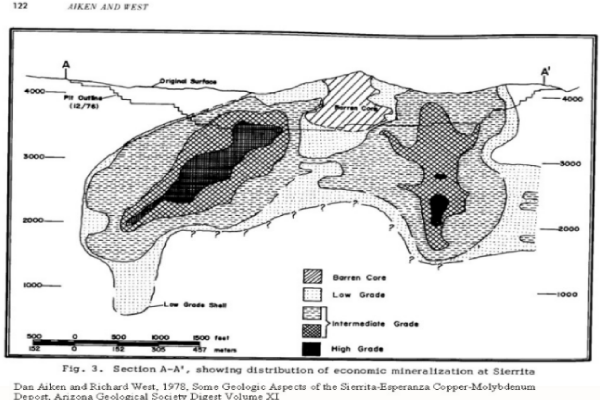
Sierrita is a relatively low-grade copper-molybdenum deposit emplaced into igneous rocks. The mine also contains gold, silver, lead, and zinc that are associated with the copper ore. The molybdenum contains rhenium. For many years, Sierrita was the only domestic producer of rhenium, a metal used in high-temperature, super-alloy turbine blades for jet aircraft and other land-based turbines. The Sierrita plant processes output from other mines on a toll basis. Recently, Kennecott (Rio Tinto) in Utah began to refine its own rhenium.
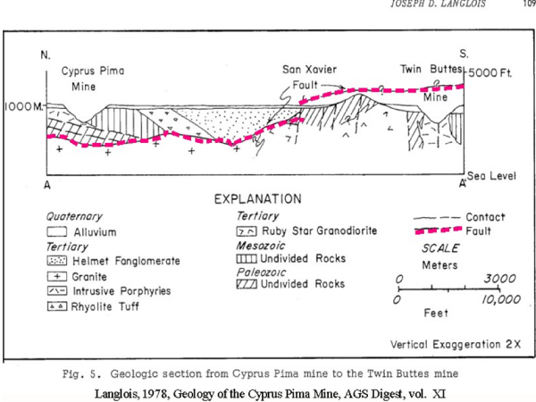
The Twin Buttes mine is located about 5 miles northeast of Sierrita and has similar copper mineralization. This mineralization was emplaced into limestone and quartzite wall-rocks. Twin Buttes, originally, was probably much larger than Sierrita and its mineralization extends to well below sea level. However, subsequent tectonic activity sliced up the original deposit and spread it out like a fanned deck of cards. The current understanding of the geology proposes that the Pima-Mission mine, 7 miles north of Twin Buttes, the San Xavier orebody, and perhaps even Saginaw Hill mineralization, some 20 miles north of Twin Buttes, were all originally part of the Twin Buttes deposit. A large, low-angle fault, the San Xavier fault, transported slices of Twin Buttes northward about 28 million years ago. Drilling has confirmed the existence of the fault beneath the Mission-Pima mine.
Shafiqullah and Langlois, who did extensive age-dating of rocks in the district propose the following sequence of events:
“The geologic complexity of the Pima district is largely due to superposition of two magmatic and three tectonic episodes within the last 65 million years. The first magmatic and tectonic episode occurred during Laramide [ca. 65-55 million years ago] when plutonic rocks…intruded Paleozoic and Mesozoic sedimentary and volcanic sequences, as well as Precambrian granite. This…culminated in hydrothermal mineralization…from 64 to 57 million years ago. The second intrusive and tectonic episode occurred during the mid-Tertiary at which time the coarse-grained Helmet Fanglomerate was being deposited in tectonic basins 31 to 27 m.y. ago…The complex and imbricate San Xavier fault developed at the culmination of the mid-Tertiary magmatic-tectonic episode. A third tectonic episode, characterized by normal faulting, occurred during the past 12 million years…[as part of] the Basin and Range disturbance….” (Fanglomerate is poorly sorted and poorly stratified alluvial fan debris, slope wash, colluvium, and talus.)
Shafiqullah and Langlois also suggest that the Sierrita and Twin Buttes deposits, now 5 miles apart, where once adjacent.
All this structural complexity makes life interesting for the exploration geologist, and sometimes complexity spawns opportunity. The Pima-Mission orebody was completely covered by alluvium and was discovered by experimental geophysical exploration by Walter Heinrichs, jr. and R.C. Thurmond in 1950.
Because of the structural complexity, one might wonder if there are more buried orebodies along the Twin Buttes-Pima Mine trend. I know of one such body. About two miles north of Twin Buttes, just south of Helmet Peak Road, several drill holes have intersected what may be a slice of the original Twin Buttes orebody that is now entrained within the Helmet Fanglomerate. If the mineralization is continuous between drill holes, there could be about 100 million tons grading 0.75% copper there (that’s high grade for this type of deposit). This occurrence needs more exploration to determine if it would, in fact, make an economic deposit.
More surprises may lie southeast of the Sierrita mine. Only time, and the willingness to expend funds for exploration, will tell.
References:
Aiken, D. and West, R., 1978, Some geologic aspects of the Sierrita-Esperanza Copper-molybdenum deposit, Arizona Geological Society Digest Volume XI
Cooper, J.R., 1960, Some geologic features of the Pima mining district, Pima County, Arizona, USGS Bulletin 1112-C.
Heinrichs, W.E., Jr. and R.C. Thurmond (1954) A Case History of the Geophysical Discovery of the Pima Mine, Pima County, Arizona. Geophysics: 19(3)(July, 1954): 600-612.
Langlois, J.D., 1978, Geology of the Cyprus Pima Mine, Arizona Geological Society Digest XI
See also:
A Brief Geologic History of Arizona Chapter 1 Precambrian
A Brief Geologic History of Arizona Chapter 2 Cambrian and Ordovician time
A Brief Geologic History of Arizona Chapter 3 Silurian to Permian
Arizona Geological History Chapter 4: Triassic Period
A brief geologic history of Arizona Chapter 5: Jurassic Time
A brief geologic history of Arizona Chapter 6: Cretaceous Time
A brief geologic history of Arizona Chapter 7, the Cenozoic Era
Old mines of the Tucson Mountains
The Pontatoc mine lost in a north Tucson neighborhood
The old Jacobs tungsten mill in Tucson