

The Arizona Geological Survey (AZGS) is beginning a two-year project to inventory landslide sites throughout Arizona. They will inventory historic and prehistoric landslides, focusing initially on highly populated areas and transportation corridors where hazards and risks are greatest. Recall that the 2013 landslide that took out Highway 89 near Page, Arizona, was on a historic landslide site.
Landslide hazards are on the increase as development expands into mountainous terrain and as record wildfires and monsoon rains fuel dangerous, fast moving debris flows, a type of landslide activity.
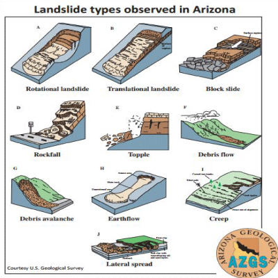 AZGS has an existing, two-page, information sheet “Landslides in Arizona: Just the facts” which you can download now. That sheet shows several graphics including the types of landslides.
The proposed landslide database will allow local authorities to assess risk and take steps to minimize that risk.
According to AZGS, “This program will create an online interactive Arizona Statewide Landslide Inventory Database (AzSLID) of known and newly identified landslides; and an outreach and education program to inform local, tribal, county, state and federal stakeholders and the general public regarding the distribution, nature and scope of landslides and landslide hazards in Arizona.”
The program is funded by a grant of $150,656 from the Arizona Department of Emergency and Military Affairs (DEMA) obtained from the federal Pre-Disaster Mitigation program and by $50,219 from AZGS.
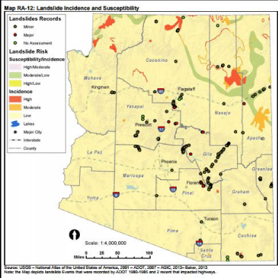
The Arizona Department of Emergency and Military Affairs (DEMA) has a hazard mitigation program, part of which deals with landslides (see here). In that report they show a map of landslide incidence and susceptibility. I notice that the map does not show the debris flows in the Santa Catalina Mountains which swept through Sabino Canyon in recent years. That alone shows the need for a better inventory program.
Inventorying landslides and developing hazard and risk map assessments now will make Arizonans, their property and infrastructure safer in the years ahead.